Building a system where annotation, computer vision, and geospatial data work as one continuous workflow
By Taimoor Khan - Software Engineer · Published on
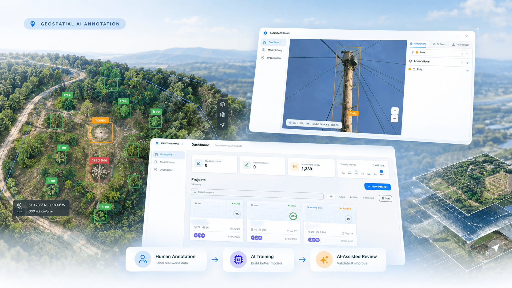
Computer vision systems (the field of Artificial Intelligence [AI] that trains computers to ‘see’ and understand digital images and videos) are only as good as the data behind them. For large-scale geospatial imagery, creating high-quality labelled data is expensive and difficult to scale. A single drone survey can produce a massive orthomosaic (a large, top-down map made by stitching together many smaller aerial photographs) containing thousands of objects. Tiling them can compromise the fine details annotators need, especially if those annotators were not present during data collection (which is typically the case), while efficiently rendering an entire Orthomosaic remains challenging for all conventional annotation tools.
Orman needed to address these shortcomings to build a platform that maintained high resolution but also accelerated the annotation task so that new objects could be added to the service with the greatest speed without compromising accuracy. The approach taken is illustrated below:
- Render large orthomosaics at full detail;
- Annotate the relevant objects using human agents;
- Train the integrated AI model;
- Use AI to accelerate annotation, validate predictions, and progressively improve the model through human-validated training cycles.
Orman’s platform (known as Aspan) brings high-performance orthomosaic rendering, annotation, multispectral and geospatial data, AI inference and validation into a single workflow, preserving image detail while progressively reducing manual annotation effort.
Rendering Large Orthomosaics
Traditional annotation tools often struggle to render and navigate extremely large orthomosaics. A single drone survey can contain many millions of pixels while requiring users to inspect very small objects accurately. Aspan is a high-performance desktop rendering service that allows users to navigate large orthomosaics directly and annotate objects while preserving the original image detail; so, in short summary, Aspan allows for
- Large orthomosaics;
- High-Performance Rendering;
- Simple and intuitive Navigation;
- Precise human Annotation; and
- Precise AI Annotation.
This allows annotators to work at full image detail without first breaking the orthomosaic into smaller images.
Dataset Export and Tiling
Large orthomosaics can be annotated directly in their original high-resolution form, preserving the fine details required by annotators. When exporting a dataset, the platform can tile the orthomosaic into model-ready images, with configurable overlap to ensure objects near tile boundaries are retained.
- High-Resolution orthomosaic;
- Dataset Exports: it’s important that it exports annotated imagery according to user requirements, allowing datasets to be prepared for different AI training and testing purposes.
- Configurable Tiling: Allows users to define tile size and overlap based on their model or dataset requirements, helping retain objects and provide consistent training data; and
- Model-Ready Dataset.
This allows users to maintain full-resolution imagery during annotation while producing suitable training data when the dataset is exported.
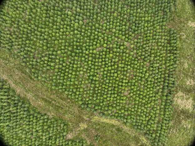
Figure 1: A stitched together orthomosaic
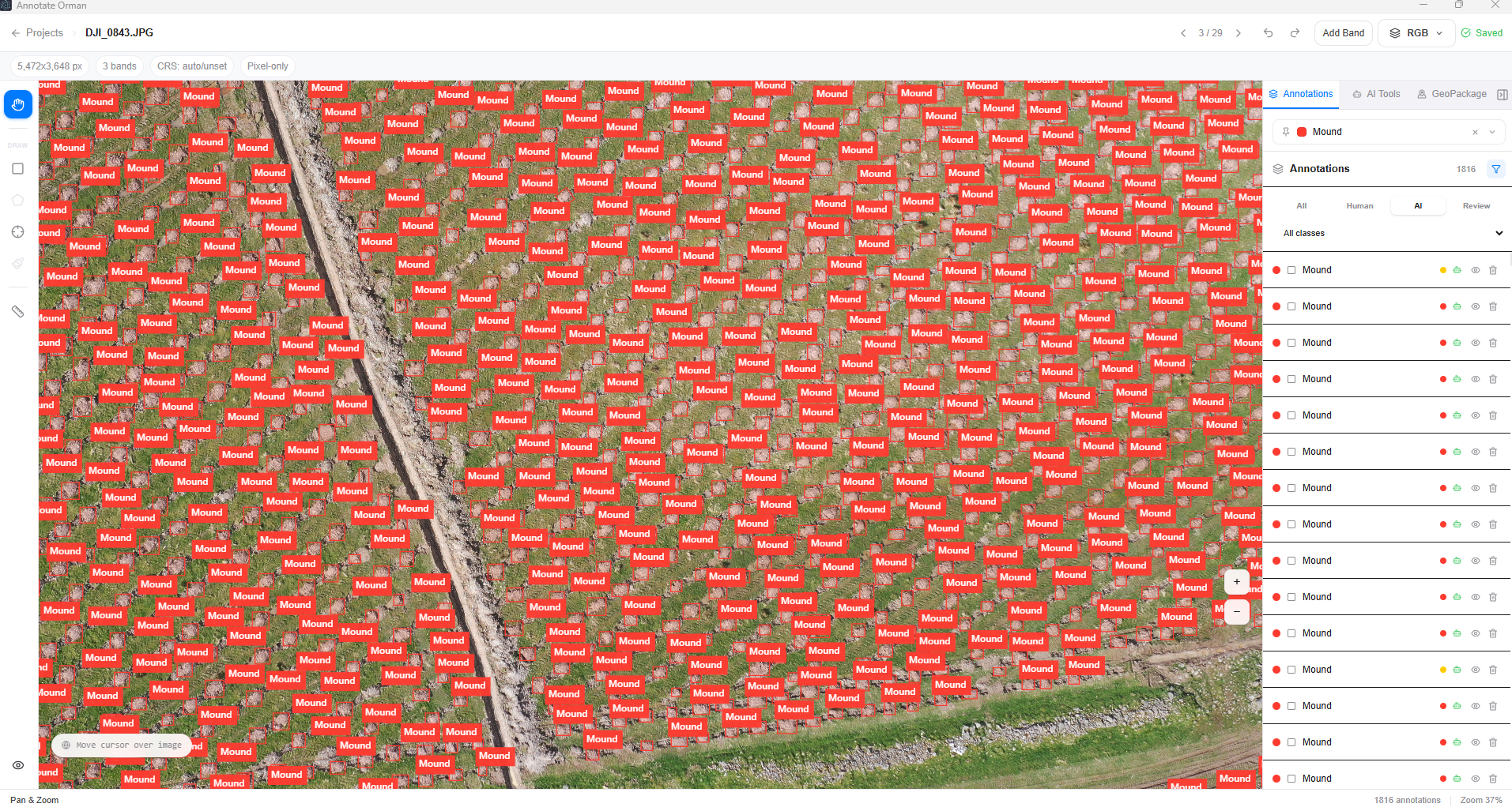
Figure 2: ‘Labeled’ high-definition example for annotator view including AI labels
Making Multispectral Data Usable Inside the Annotation Workflow
Geospatial computer vision offers more possibilities if you extend beyond images that display the standard Red Green Blue (RGB) spectrum Aspan supports flexible multispectral data ingestion, allowing users to work with spectral information directly within the annotation environment. This is important because many living objects such as trees can display stress (disease, drought etc) outside of RGB.
Users can:
- Upload individual spectral bands alongside each RGB or other image;
- Upload single-band images and associate them with the corresponding image;
- Automatically detect and interpret stacked multispectral TIFFs (Tagged Image File Format that stores multiple image bands or pages—such as red, green, blue, near-infrared, and red-edge—within a single file);
- Switch between available spectral bands in real time while viewing the same image; and
- Apply different colour maps to each band for enhanced visual interpretation.
This enables users to inspect the same imagery across multiple spectral representations while keeping imagery, spectral bands, annotations, and geospatial context within a single workflow.
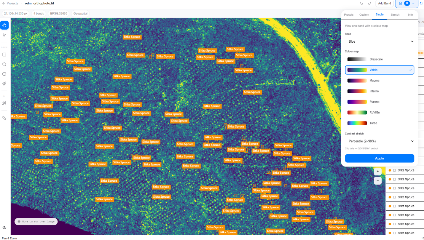
Figure 3: Multispectral Image Rendering
Bringing Geospatial Context into the Annotation Workflow
Computer vision annotations often depend on where the imagery was captured. Aspan supports GeoPackage (.gpkg) files (an open, standards-based SQLite database file container used to store, transfer, and manage multispectral satellite or drone imagery alongside geographic vector features), allowing site boundaries and geospatial layers to be overlaid directly on imagery.
This provides annotators with additional context, such as:
- Site boundaries and locations overlaid on imagery;
- Identifying which site or survey area an image belongs to;
- Site-specific information displayed alongside the imagery;
- Relevant information such as species, survey area, or other known site characteristics; and
- Spatial context that helps annotators make more informed labelling decisions.
For example: if an image is taken from a site which where a planting regime is from species X then it is more likely to be species X than species Y.
Instead of annotating an image in isolation, the annotator can understand where the image came from and what is known about that location, improving consistency and reducing annotation ambiguity. The result is a workflow where imagery, annotations, multispectral data, and geospatial site context are brought together in a single annotation environment.
The Annotation-to-AI Feedback Loop
Aspan includes an integrated AI model that learns from human-created annotations and progressively assists the annotation process. This is a game changer for the process of adding new objects into the product. Traditionally, annotation has required labelling of 10s of 1000s of images in order to learn, Aspan has compressed that process with no reduction in data quality – to give an indication of how efficient the Orman team, using Aspan can do in a single day what previously took two weeks. The process is as follows:
Step 1: Human Annotation
Annotators create and validate bounding boxes within the project. These annotations become the learning data for the integrated AI model. The platform tracks labels, classes, contributors, class distribution, and review activity. Once sufficient human-validated annotations are available, the model can be trained on the project’s annotations as follows:
Human Annotation => Integrated AI Model Training => AI-Assisted Annotation => Human Validation=>Improved Integrated AI Model
Step 2: Training the First Model
The integrated AI model learns directly from human-validated annotations created within the project. Once sufficient approved labels are created the model can be trained and a Model Vr1 provided.
Step 3: AI-Assisted Annotation
Model V1 next becomes part of the annotation workflow. Instead of manually creating every bounding box, the integrated AI generates predictions that humans can review, correct, or approve. The AI handles repetitive annotation work while the human remains in control of the final labels.
Human-in-the-Loop AI Improvement
AI-generated annotations are not automatically accepted. However smart, the integrated model can produce incorrect detections, miss objects, or show inaccurate bounding boxes, so every prediction must be reviewed and validated by the annotator.
Only Human-validated annotations are used to improve subsequent versions of the integrated AI model.
From Model V1 to V2
As annotators validate more predictions, the project builds a larger, higher-quality dataset for the AI capability within the annotation tool.
This creates a continuous ‘human-in-the-loop’ improvement cycle, where the AI progressively reduces repetitive annotation work while humans remain responsible for label quality.
Building a Reusable Model Ecosystem
Models trained within the annotation tool then become reusable AI assets across projects. Projects may form part of an organisations own unique data, or may form part of a generically available platform model available for all subscribers:
Organisation Models: Visible only to users within the organisation and available for use across its projects.
Platform Models: Available to platform users, who can use the model in their own projects and further improve it through their validated annotations.
This creates a growing model ecosystem where existing AI capabilities can accelerate new projects instead of starting from scratch.
Dataset Intelligence
High annotation volume does not necessarily mean high-quality data. The platform provides project-level analytics to help teams understand dataset quality, balance, and progress.
Users can monitor:
- Total labels and class distribution;
- Labels per contributor;
- Project and annotation progress;
- Review and validation activity; and
- Dataset composition
This gives teams visibility into what has been labelled, how it is distributed, and where the dataset needs improvement.
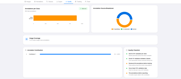
Figure 4 – Data Intelligence All Information About Dataset
The Engineering Principle
The platform is built around a simple principle: ‘AI reduces annotation effort, while human annotations continuously improve the AI’.
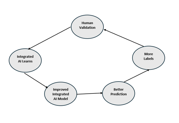
Figure 5 – continuously improve the AI
This creates a continuous human-in-the-loop AI workflow where the annotation tool becomes more effective as high-quality annotations accumulate.
The Result
Aspan has created more than an annotation interface or a standalone training system. Aspan provides a computer vision annotation platform with integrated AI, geospatial processing, and continuous Integrated AI model improvement.
By uniting high-resolution Orthomosaic rendering with AI-assisted annotation, the platform reduces repetitive effort while human-validated data continually strengthens the model.